Field of Science

Planet Earth now in 3D: First TanDEM-X DEMs

The two German twin-satellites "Terrasar-X" and "Tandem-X" will in the next three years survey Earth with a new revolutionary method, but first glimpses of the new technology are now aviable.
„Tandem X“ orbits earth since 2007, but only four weeks ago he was joined by his twin "Terrasar-X". To gather the data for a three-dimensional model both satellites have to orbit parallel to each other, and observe the same point from different angles. The two satellites have not jet reached their definitive orbit, but on the 16. July they approached each other up to 370 kilometres, enabling mission control to collect preliminary data with a resolution of some centimetres. In the last days the satellites were moved to fly in tandem 20 kilometres apart, the definitive survey of the Earth’s surface will occur then with a satellite to satellite distance of 200 to 500m, to reach a never before seen mapping resolution and accuracy.


Fig.1. The first image created by the researchers of the German Space Agency (Deutschen Zentrums für Luft- und Raumfahrt - DLR) shows a three-dimensional model (vertical exaggerated) of a glacier tongue on the remote October Revolution Island, part of the larger Severnaya Zemlya archipelago in the Russian Arctic (79° northern latitude). (figure by Infoterra GmnH), here the zoomable version.

Online Resources:


Infoterra GmbH (Germany) (2010): Image Gallery. (Accessed 22.07.2010)

March 12, 1928: The geological induced collapse of the St. Francis Dam

Sometimes ignoring the geological structures and resulting problems of construction sites can have disastrous consequences. Following the post of the Stava dam collapse, a similar event from the New World, where ignoring the geological circumstances caused death and destruction:

At the end of the 19th century, the city of Los Angeles was lacking an important factor limiting the economic development - the water supply was insufficient and couldn't satisfy the demand. William Mulholland, an Irish immigrant, and a very ambitious man had managed to become a self-educated engineer and the superintendent of the Los Angeles Bureau of Water Works and Supply. He seemed the right man for the job to bring the needed water to the city.
So he planned and constructed a system of aqueducts that collected and redirected water from the Sierra Nevada to Los Angeles. Almost
72 kilometers north from Los Angeles the main aqueduct ended in the San Francisquito Canyon, where two hydroelectric power stations were built. Mulholland decided to amply the original project and constructed a supplementary dam to regulate the water flow.

Fig.1. The completed St. Francis Dam (figure from CHAMP 1983).


The construction site in the San Francisquito Canyon follows a tectonic lineament that separates conglomerates and sandstones with gypsum from schists with layers of talcum. In addition to these very unstable rocks, surrounding the contact between the two lithologies were lenses of serpentinites, weak rocks inadequate to support a heavy building like a dam.
In 1926 the St. Francis dam was inaugurated, 61 meters high, with a span of 210 meters and at the base 50 meters thick. Soon after the completion of the dam water leaks were observed, but it seemed normal for such a large reservoir. On the morning of May 12, 1928, the technician Tony Harnischfeger observed a leak on the eastern side of the dam. Mulholland was informed and arrived soon thereafter to inspect the damage. The water was clear, sign that no sediment was eroded. At 23.57 p.m. a power blackout in Los Angeles marked the collapse of the dam.
 
Fig.2. The remains of the St. Francis Dam (figure from CHAMP 1983).


The resulting waves inundated highway 126 in the Santa Clara Valley, destroying at least 50 cars and killing an estimated 300 to 600 people, the exact number of victims remains unclear to this day. The waves finally reached the Pacific, more than 70 kilometres distant from the San Francisquito Canyon.

References:

CHAMP, C. (1983): Planet Earth - Flood. Time-Life-Books. Amsterdam: 176

July 19, 1985: The Val di Stava Dam collapse

The Val di Stava Dam(s) collapsed on July 19, 1985 at 12.22.55. The mudflow caused by the break of two dams above the village of Stava, near Tesero, northern Italy, resulted in one of Italy's worst disasters, killing 268 people, destroying 62 buildings and demolishing 8 bridges.

Fig.1. The destruction in the valley (image from Wikipedia).

The dammed basin was used to collect and store the slag heap of a Fluorite-mining company. The dam was situated 150m higher and in a distance of 800m from the last buildings of the village of Stava. In 1969 the first basin reached a height of 25m, and it was decided to build a second basin above the existing one.
The dams were build simply by separating coarse material from water and mud, and using the sand, pebbles and rocks as material for the basin itself, a mode of construction adequate only for small basins. A second basin was then build direct overlying, and leant in part on, the first. In 1969 the height reached by the upper basin was 34m, only 9m were authorized, the two dams were in total 50m high.


Fig.2. The two basins, after a contemporary photography (figure from ANNOVI).

Fig.3. The remains of the two basins after the collapse (figure from LUCCHI 1995).

In 1974 the administration of the commune of Tesero (distant ca. 5 kilometres) demanded a security and stability control for the two basins, the (today as incomplete regarded) study was carried out in 1975 and concluded that the gradient of inclination of the dams was “extraordinary” and the stability of the construction “at the limits”. Nevertheless the mining company supplied to the authorities a positive security report, and the dam in the following years could be heightened, with the only compromise that the inclination was reduced to 40°.
Between 1978 and 1982 the basins were not in use, only in 1982 until 1985 they were used to store the spoile pile of the mine “Prestavel”. In these twenty years the dams and basins were never again controlled, not by the mining company, neither by the public administration responsible for mining activities in the Province of Trento.

The upper dam broke first, slumping in the subjacent, and so leading also to the collapse of the lower dam. Around 180.000 cubic metres (from the total volume of the dams of 300.000) of mud, sand and water were released into the Rio di Stava valley and toward the village of Stava at a speed of 90 km/h. Additionally 40 to 50.000 cubic metres were eroded by the primary wave from the underground and incorporated in the flow. The mudflow reached the village after 50 seconds crashing through the village, the flow then continued for three minutes until it reached the Avisio River 4.2 km away, destroying everything in its path.


Fig.4. Aerial imagines of the Stava Valley before, and after the disaster (image from W.I.S.E.)

An investigation into the disaster found that the dams were poorly maintained and the margin of safe operation was very small.
As last trigger of the failure is considered a leak of water, caused by a pipe in the upper dam, used to drain water, which had been bent by the weight of sediments. The increasing water pressure of the bunged up dam, in combination with the water saturation weakening the sediments of the dam wall, caused probably the collapse.

Online Ressources:

ANNOVI, A.(): La frana di Stava. Accessed 18.07.2010
LUCCHI, G. (1995): Stava perchè. Editore Cuca & Genovese. Trento
World Information Service on Energy (13.05.2009): The Stava tailings dam failure (Trento, Italy). Accessed 18.07.2010

C.S.I. Geology: Forensic geoscience and its application to criminal investigations

The use of geology in forensic investigations can help to compile an "environmental profiling" of a person, doing so it's possible to link the suspect to the scene of crime and provide circumstantial evidence for his guilt.
It was in his fictional (but by real scientific progress inspired) cases of Sherlock Holmes that Sir Arthur Conan Doyle solved as first criminal cases by investigating soil evidence (for example in "A Study in Scarlet" and subsequent novels between 1887 - 1927).
At almost the same time the Austrian professor of criminology Hans Gross mentions in his "Handbuch für Untersuchungsrichter" (Handbook for Examining Magistrates, published in 1893) that the petrographic study of dirt on shoes probably can tell where a suspect went previously. Based on these ideas the France physician Edmund Locard in 1910 established the basic principle of environmental profiling (Exchange Principle):


"Whenever two objects come into contact, there is always a transfer of material. The methods of detection may not be sensitive enough to demonstrate this, or the decay rate may be so rapid that all evidence of transfer has vanished after a given time. Nonetheless, the transfer has taken place."

But it was the German chemist Georg Popp who in 1908 was the first investigator to solve the real murder of Eva Disch by considering soil as a evidence.
Popp reconstructed the movements of the suspect analyzing the dirt found on his shoes: the uppermost layer, thus the oldest, contained goose droppings and other earth materials that were comparable with samples in the walk outside the suspect's home. The second layer contained red sandstone fragments and other particles that were comparable with samples from the scene where the victim had been found. The lowest layer, thus the youngest, contained brick, coal dust, cement and a whole series of other materials that were comparable with samples from a location outside a castle where the suspect's gun and clothing had been found. The suspect affirmed that he had walked only in his fields on the day of the crime. Those fields were underlain by porphyry with milky quartz, but Popp found no such material on the shoes although the soil had been wet on that day, so he proved that the suspect was lying (MURRAY 2005).


In the last two decades the significance of forensic geology increased steadily, it is applied not only to connect single suspects to criminal cases, but also to trace the provenience of drugs or smuggled goods, including wildlife, explosive and reconstruct and uncover war crimes, not to mention the possible applications to detect cases against environmental law.

In 1997 the United Nations International Criminal Tribune for the Former Yugoslavia (UN ICTY) started exhumations of five mass graves in NE Bosnia associated with the massacre of civilians in and around Srebrenica in July of 1995. It was known from intelligence that 3 months after the initial executions of civilians the primary mass graves had been exhumed and the bodies transported over a 1-3 day period to a number of unknown, but at least 19, secondary grave sites.

Nevertheless to prosecute the suspects involved in the massacre during the process in The Hague, it was necessary to prove that the recovered bodies came from Srebrenica, and that the later dislocation of the graves was intentionally to hide the crimes. The two sites were intensively probed, and samples of the grave fills and surrounding soils and bedrock collected.

During sampling it must be considered that the decomposition of organic matter, in combination with groundwater, can create chemical reactions that alter the surrounding rocks and soils, it is also necessary to discriminate what should be sampled. For example, the surrounding undisturbed bedrock and covering soil should be examined separately. The soil itself can be subdivided, depending of bedrock, climate and soil-age in different pedogenetic horizons.
The material inside a refilled pit can consist of reworked soil or rocks from the underground or surrounding area, or material brought together with the corpses to the site.
The soil samples can be screened by their content of minerals and rocks, the size and form of single mineral or rock grains, biochemistry of humic substances, microbiology, invertebrates, plant macroremains and the small, but very abundant pollen and spores grains, diatoms. These parameters can vary in so many ways, that in practice every soil can be regarded as unique. Comparing the parameters between samples recovered from the victim or suspect and collected at the crime sites so can establish a connection between them.
For example during the investigations in Bosnia a striated clast of serpentinite found in one of the secondary gravesites proved a connection to a specific primary sites, only there a serpentinite dyke was outcropping. In a similar way the presence or absence of clay minerals, depending on the surrounding geology of the primary burial site, connected or excluded the primary to the secondary sites.

Fig.2. The principle behind forensic geology is the assumption that rocks and trough erosion and alteration resulting soils, their properties and their combination are unique features of specific sites. Here an example for a typical soil with his pedogenetic horizons and some "complications":
Fissures that act as sediment and also bone accumulation traps can develop not only in carbonates, but also in evaporitic sediments. Near the small village of Westeregeln (Thuringia, Germany) past quarrying activity for clay has exposed underlying Mesozoic gypsum and limestone formations, which in the upper part show an intensive “karst” network, refilled with Pleistocene sediments and fossils. The uppermost part of the stratigraphic column of the infilling sediments is represented by a postglacial soil, developed on Loess - aeolian sediment deposited during the last great glacial period. These sediments cover ancient matrix supported breccias, presumably generated by partial collapse of former caves or fissures.
Note the secondary infillings of the burrows of animals and the different colors of the layers due their petrological and biological differences.

References:


BROWN, A.G. (2006): The use of forensic botany and geology in war crimes investigations in NE Bosnia.Forensic Science International 163: 204-210
PYE, K. (2004): Forensic Geology. In R.C. Selley, L.R.M Cocks and I.R Plimer (Ed.) Encyclopedia of Geology. Elsevier, Amsterdam
RUFFELL, A. & McKINLEY. (2005): Forensic geoscience: applications of geology, geomorphology and geophysics to criminal investigations. Earth-Science Reviews 69: 235-247

Online Ressources:
CHESELDEN, W. (1733): Osteographia, or The anatomy of the bones. - Fig.1.Frontispiece
MURRAY, R.C. (2005): Collecting Crime evidence from Earth.

The dinosaur as kangaroo

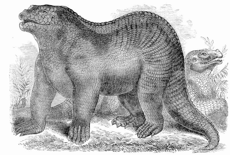
In 1841, during a lecture in which he coined the term "dinosaurs", the English palaeontologist Richard Owen described some of the new established species of this group of vertebrates, including the Iguanodon. He imagined the Iguanodon like a chimera in part crocodile, in part elephant with elements of a hippopotamus, with a kind of horn at the end of the snout, in the end reminiscent in aspect of a modern rhinoceros.
In 1854 the sculptor and artist Benjamin Waterhouse Hawkins created some models of dinosaurs and other prehistoric animals, under the supervision of Owen, to be displayed in the gardens of the Crystal Palace in south London.


Fig.1. In 1860 Hawkins published "A Comparative View of the Human and Animal Frame" as a work intended by him "to give a comparative view of the variation in form of the bony skeleton or framework of those animals most frequently required by the artist, designer, or ornamentist".

The approach for the reconstruction and representation of the animals adopted by Owen and later by Hawkins can be explained by considering the historical context.
Hawkins was a follower of the theory of "types" developed by the French naturalist Cuvier - Cuvier asserted that in the animal anatomy there were four basic types of "animal forms or archetypes" (a concept comparable in it's significance to the modern concept of Phyla). Owen maintained a similar approach, claiming that the possible anatomical "types" of animals are limited.
Therefore between apparent different groups of animals, like reptiles and mammals, there exist similar types and forms of life. The Victorian dinosaurs were the reptilian equivalent of quadruped large carnivore or herbivore mammals, and so Hawkins reconstructed the dinosaurs as large mammals with only the scaly surface identifying them as reptiles.

Owens's dinosaurs had also two other advantages: 1) The, compared to modern represents, superior prehistoric reptiles confuted the proposed "scala naturae", the ladder of progress in geological time, of the young "evolutionists" movement, and 2) the super - reptiles of course were once inhabitants of England, nature itself provided evidence that Britain was a higher developed nation already in the geological past.

The exhibition in London was a great success, and in 1868 Hawkins was invited by the American Museum of Natural History in New York to organize a similar spectacle in Central Park.

Fig.2. The laboratory of Hawkins in New York. It's interesting to note that in front of the dinosaur is collocated a (presumably giant) deer in a very similar pose.

He designed an enormous stage, where dinosaurs and other prehistoric animals were shown during predation, in battle and quiet browsing. But the organized crime in the city, financing the project, decided that the "business" would not earn as much money as planed, and stopped the work destroying the models in preparation. An appalled Hawkins went back to Princeton, from his New - Yorker project only a few sketches and drawings survived.
To celebrate the centenary of the declaration of independence from 1876 to 1878 he began to work again on a model of a dinosaur, this time a Hadrosaurus, a species described in 1856 by the American palaeontologist Leidy. Observing the disproportion in size of the limbs, Leidy in 1858 had proposed a bipedal posture for the animal. The upright standing model of Hadrosaurus displayed at Princeton is today considered the first dinosaur to be reconstructed in a (more) correct manner.

Then in 1877, in a coal mine near the Belgian town of Bernissart, 31 perfectly preserved skeletons of Iguanodon were discovered.
The outstanding preservation allowed the palaeontologist Louis Dollo (1857-1931) to describe in detail the anatomy and biology of the animals. Dollo confirmed the reconstruction of Leidy, the forelimbs seemed too fragile to support the body, and refuted the model of Owens rhinoceros.
But doing so, a problem emerged: to which modern animals should artists refer for the reconstruction of body and especially posture of the dinosaurs?
Initially Dollo used as reference frogs, then ostriches and other ratites, to shift finally to the kangaroo in a resting pose and using it as a model.


Fig.3. Figure showing a phase in the reconstruction of a skeletons of Iguanodon from Bernissart, note in the background a skeleton of a kangaroo, animal used by Dollo as a reference model for the posture of the dinosaur (figure from GAYRARD-VALES 1987, the Institut Royal des Sciences Naturelles de Belgique, Brussels).

The famous bipedal reconstruction of Dollo's Iguanodons will influence later generations of palaeoartists.

Charles R. Knight (1874-1953) was an American artist specializing in animal models and drawings. In 1896/97 he produces in collaboration with Edward Drinker Cope, palaeontologist of the American Museum of Natural History, an oil painting depicting a group of dinosaur of the genus Laelaps during the act of fighting, doing even (at least it seems) a somersault!
In an early article published in “The American Naturalist” (1868), Cope himself evokes the figure of a kangaroo:

"...joined with the massive tail points to a semi erect position like that of the Kangaroos while the lightness and strength of the great femur and tibia are altogether appropriate to great powers of leaping."

The image of the reconstruction by Knight, but influenced by Cope, is first exposed in public and then published in the "Century" magazine, from where it will soon be copied by other newspapers and enter the collective mind and popular culture.


Fig.4. C. Knigth (1896) "Laelaps".

Not only the image of dinosaurs resembling, even acting, like kangaroos so for decades will spread in form of depictions, it is even immortalized in various (pulp-)stories and in modern classic novels.

In a story of 1891 in “Hardwicke's Science-Gossip”, a short-lived 19th century pop-sci magazine, we read:

“The Laelaps was forty feet long, stood twenty-five feet high on its hindlegs, and was built like a kangaroo. It was the most astonishing jumper that ever existed, with teeth for cutting and sharp claws on the front feet, evidently designed for tearing out its adversary's eyes.”

Sir John William Dawson, geologist, depicts Laelaps in his 1873 pop-sci book “The Story of Earth and Man” as follows:

“Had we seen the eagle clawed Laelaps rushing on his prey; throwing his huge bulk perhaps thirty feet through the air, and crushing to the earth under his gigantic talons some feebler Hadrosaur, we should have shudderingly preferred the companionship of modern wolves and tigers to that of those savage and gigantic monsters of the Mesozoic.”

The writer Arhur Conan Doyle - known for his Sherlock Holmes stories - in 1912 publishes "The Lost World". The sudden appearance in the novel of a dinosaur he describes as follows: "I said deliberately" jumping", because the monster moved like a kangaroo, and jumped straight on its powerful hind legs - the forelegs were folded in front of the chest. It seemed much bigger then an erected elephant. But despite it's huge size, it's movements were very swift." (Doyle 1912: p. 183).

References:

DWORSKY, A. : Die sich wandelnde Idee des Dinosauriers. Exposé zur Dissertation
GAYRARD-VALY, Y. (1987): Les fossiles - empreinte des mondes disparus. Editions Gallimard, Paris: 208

Online Resources:

ORR, D. (03.08.2010): Leaping Laelaps, Indeed. Accessed 04.08.2010

“Stuores”, a pasture and it’s "coréc"

In 1839, during his voyages trough the Alps, the German geologist H.L. Wissman noted that native people of the Gader Valley in the Dolomites sell petrifactions to earn some supplementary money, but "They demand so much money, that it can be paid only the half sum that they want."

Since the beginning of the geological exploration of the Alps from 1800 onwards, farmers and pastors, often visiting the high situated pastures were fossil-rich rocks crop out, collected fossils to sell it to the first tourists, naturalists and geologists visiting the region.

In the ladinian, an old idiom, speaking valleys of the Dolomites fossils were called simply "coréc", and regarded as beautiful, but mysterious natural things.
On the plateau between the two innermost bifurcations of the Gader valley is situated the so called "Stuores", a pasture where the locals of the (once) small village of St. Cassian let graze their cattle and sheep.
Here escarpments of large mass wastings expose a succession of marls, limestone and breccia-layers, and single, large limestone boulders, embedded within the marls. These deposits represent turbitides, composed of riff detritus that 240 million years ago break of from the reefs and atolls, still visible at the horizon in form of the steep peaks of the Dolomites, and precipitated in the depths of the sedimentary basin between them.


Fig.1. View of outcrops of marls on the Stuores pasture.

Fig.2. Dasycladaceae in limestone.

In 1830 the German aristocrat Georg Graf zu Münster got interested in the fossils collected in the surroundings and pastures of St. Cassian.

Fig.3. Georg Graf zu Münster (1776 - 1804).

"Trough Leopold von Buch I become conscious for the first time about these petrifactions. Many years ago he brought some of them from Tyrol, and during his visit he was so kind to concede some of them to me, so also the spine of an unknown echinoid. This led me to collect from these petrifactions as much as possible. After I studied and draw carefully some thousands specimens, comprising these deposited in the Ferdinandeum of Innsbruck, and in the local Mineral contour, I tried to identify the different kinds and species as exactly as possible. Until them nobody cared about this worldwide fossil richest site."

In 1834 Münster publishes his results in his opera entitled " Über die Kalkmergel-Lager von St. Cassian in Tyrol und die darin vorkommenden Ceratiten" (About the marl-beds of St. Cassian in Tyrol and in it occurring Ceratites), without having visited the Gader Valley once. Münster is a very wealthy man; he can afford large sums to buy collections and species.
Proud he claims that from 128 different studied fossils 112 are new to science, and only 16 of the species are know to occur on others fossiliferous sites.


Fig.4. Some fossils of the surroundings of St. Cassian, by LAUBE 1865 (Plate 2.).

But Münster is also a great promoter and patroniser of palaeontology, part of his collections he cedes to public institutions, for example only to the University of Cambridge he donates more then 20.000 fossils!
Finally in 1840, after his retirement, he finally has the time and the possibility to carry out the difficult voyage into the Dolomites to the Stuores pastures. His impressions and ulterior research on the fossils found there he publishes in collaboration with the geologist Wissman in 1841, their work is entitled "Beiträge zur Geognosie und Petrefactenkunde des südöstlichen Tirols" (Contributions to the Geology and studies on petrifactions of the southeastern Tyrol), in which the two naturalists propose also the (still today) official name for the studied geological formations: Cassianer Schichten (Layers of St. Cassian) and Wengener Schichten, after the two nearby villages.


Fig.5. Some fossils of the surroundings of St. Cassian, by LAUBE 1865 (Plate 4.).

After the death of Münster in 1844 his collection is sold to the Paleontological Bavarian State-Museum in Munich, it comprises 150.000 specimens, and the finale price amounts to 35.000 Gulden, today's equivalent would be approximately 7 million Euros!

References:

AVANZINI, M. & WACHTLER, M. (1999): Dolomiti La storia di una scoperta. Athesia S.a.r.l. Bolzano: 150
LAUBE, G. (1865): Die Fauna der Schichten von St. Cassian. Denkschriften der Mathematisch-Naturwissenschaftlichen Classe der Kaiserlichen Akademie der Wissenschaften Vol.24. Wien

Accretionary Wedge Call: What’s about the Geoblogosphere ?

The Geoblogosphere comprises and gathers every day the newest articles from more then 200 blogs (and still counting) dealing with the most various earth related themes, ranging from geological excursions, sharing field experiences, philosophizing about earth sciences, life and art, media coverage and daily rock encounters to discussion of the newest scientific discoveries on this planet and others.
So philosophizing around (geo)blogging with Dr. Welland many questions raised:

- like how bloggeology can “impact” society and "real geology" , should and can we promote the "geoblogosphere", and are blogs private “business” or public affairs, and institutions underevaluating the possibilities given by this new method of communication ?


We will try to respond to these questions by the July 2010 Accretionary Wedge carnival, so please geoblogger(s) around the globe: make a short break of your daily field trips, put away for a moment your pet rock, and send in your contribution or post a comment for the AW, you got time until the 29 July – I then will gather the posts and present them to the GEOBLOGOSPHERE!